The Auvergne region of central France stands as one of Europe’s most remarkable volcanic landscapes, where millions of years of geological activity have sculpted an extraordinary terrain of dormant volcanoes, crater lakes, and thermal springs. This UNESCO World Heritage site encompasses the Chaîne des Puys-Limagne fault system, representing the most comprehensive example of continental rift volcanism in Europe. The region’s volcanic heritage extends far beyond mere geological curiosity, offering scientists unprecedented insights into magmatic processes, crustal dynamics, and the evolution of volcanic systems over geological timescales.
With over 80 volcanic edifices distributed across three distinct volcanic regions – the Chaîne des Puys, Monts Dore, and Monts du Cantal – Auvergne presents a natural laboratory for understanding diverse volcanic phenomena. From the iconic Puy de Dôme rising 1,465 metres above sea level to the mysterious maar lakes formed by explosive phreatomagmatic eruptions, each volcanic feature tells a unique story of Earth’s dynamic processes. The region’s volcanic activity spans approximately 65 million years, with the most recent eruptions occurring merely 7,000 years ago, making it one of the youngest volcanic regions in mainland France.
Geological formation processes of auvergne’s volcanic chain
The volcanic landscape of Auvergne emerged from a complex interplay of tectonic forces, magma generation, and crustal extension processes that began during the Oligocene epoch. The European Cenozoic Rift System, of which the Limagne graben forms a crucial segment, created the fundamental structural framework for volcanic activity. This extensional environment allowed magmas generated in the upper mantle to ascend through crustal weaknesses, ultimately reaching the surface to create the diverse volcanic landforms visible today.
Stratovolcano development in the chaîne des puys UNESCO world heritage site
The Chaîne des Puys represents one of the youngest and best-preserved volcanic chains in Europe, comprising approximately 80 volcanic edifices aligned along a north-south trending axis. These volcanoes formed through predominantly strombolian eruptions, characterised by moderately explosive activity that ejected lava fountains, volcanic bombs, and scoria fragments. The chain’s linear arrangement reflects the underlying structural control of the Limagne fault system, where ascending magmas exploited pre-existing fracture networks.
Stratovolcanic construction in this region occurred through alternating phases of explosive and effusive activity, building composite cones with complex internal architecture. The temporal evolution of individual volcanoes reveals systematic changes in magma composition and eruption style, reflecting progressive crustal assimilation and fractional crystallisation processes. Radiometric dating indicates that most Chaîne des Puys volcanoes formed within the last 95,000 years, with peak activity occurring between 35,000 and 8,000 years ago.
Basaltic lava flow mechanisms creating the cantal volcanic complex
The Monts du Cantal represent one of Europe’s largest and oldest volcanic complexes, covering approximately 2,700 square kilometres with a maximum diameter of 70 kilometres. This massive shield volcano formed through prolonged basaltic volcanism beginning approximately 13 million years ago, continuing until roughly 2 million years ago. The complex’s architecture results from the accumulation of numerous lava flows, pyroclastic deposits, and intrusive bodies emplaced during multiple eruptive phases.
Basaltic lava flows in the Cantal complex exhibit remarkable diversity in morphology and emplacement mechanisms, ranging from extensive pahoehoe flows to rugged aa surfaces. Flow field mapping reveals radial drainage patterns emanating from central vent areas, with individual flows extending up to 50 kilometres from their sources. The total erupted volume exceeds 1,800 cubic kilometres, making the Cantal complex one of the most voluminous volcanic systems in Western Europe. Geochemical analysis indicates that these basalts derived from partial melting of enriched mantle sources, with minimal crustal contamination during ascent.
Phreatomagmatic eruption evidence at lac pavin
The maar lake of Lac Pavin, near Besse-et-Saint-Anastaise, is one of the clearest examples of a phreatomagmatic eruption in the Auvergne volcanic region. Phreatomagmatic eruptions occur when rising magma violently interacts with groundwater or surface water, producing explosive steam-driven blasts that fragment both magma and surrounding rock. At Lac Pavin, the resulting crater is almost perfectly circular, around 800 metres in diameter and 92 metres deep, now filled with cold, stratified water. Sediment cores extracted from the lake bed preserve ash layers, lapilli, and accretionary lapilli typical of water–magma interaction, confirming the maar’s explosive origin.
The lake itself is meromictic, meaning that its deep waters do not mix regularly with surface layers, creating a stable stratification that traps dissolved gases and preserves fine volcanic sedimentary structures. This stratification, together with high-resolution bathymetric surveys, allows researchers to reconstruct the original crater morphology and eruptive dynamics in remarkable detail. For volcanologists interested in phreatomagmatic processes and maar formation, Lac Pavin serves as a natural archive, offering a rare window into the interplay between hydrogeology and volcanism within the wider Auvergne volcanic landscapes.
Trachytic dome extrusion patterns in puy de dôme structure
Puy de Dôme, the emblematic peak of the Chaîne des Puys, is a classic trachytic dome, formed by the slow extrusion of highly viscous, silica-rich magma. Unlike fluid basaltic lavas that can flow over great distances, trachytic magma behaves more like thick paste, piling up near the vent and creating steep-sided domes. Structural and petrological studies show that Puy de Dôme grew through successive pulses of dome extrusion, each phase adding new lobes and flow-banded carapaces that now compose the volcano’s asymmetric profile. These extrusion patterns are recorded in the dome’s internal layering, with flow foliation and fracture systems radiating from the central conduit.
Field mapping and geophysical imaging reveal that the dome is cut by a dense network of radial and concentric fractures, formed as the viscous magma cooled and contracted. These fractures controlled later hydrothermal circulation, which altered portions of the dome and deposited secondary minerals along fault planes. The presence of vertical spine-like features and brecciated zones suggests that short-lived explosive episodes punctuated otherwise effusive dome growth. For visitors standing on the summit and admiring the 360° view, it is easy to forget that this tranquil peak once hosted a complex sequence of dome-building eruptions that exemplify trachytic volcanism in continental rift settings.
Distinctive volcanic landforms across auvergne’s three volcanic regions
Across the Auvergne, the three main volcanic regions – Chaîne des Puys, Monts Dore, and Monts du Cantal – display a remarkable variety of volcanic landforms. Each region preserves a different stage in the evolution of a volcanic system, from youthful scoria cones and maars to deeply eroded stratovolcanoes and extensive lava plateaux. Understanding these volcanic landforms not only helps us decode the region’s geologic past, it also enriches your experience as you explore trails, crater rims, and panoramic viewpoints. How do these shapes in the landscape reflect what happened beneath the surface millions of years ago?
By comparing the morphology of scoria cones, shield-like edifices, phonolitic necks, and crater lakes, we can piece together the sequence of eruptive styles and magma compositions that characterised each volcanic field. In practice, this means that a hike around Puy de Pariou, a drive across the planèzes of Cantal, and a climb towards Puy de Sancy are all parts of a single, coherent volcanic story. The Auvergne volcanic landscapes therefore function as an open-air textbook, where each landform is a chapter explaining a particular process, from low-viscosity lava flows to highly explosive eruptions.
Scoria cone morphology analysis in chaîne des puys
Within the Chaîne des Puys, scoria cones such as Puy de la Vache, Puy de Lassolas, and Puy de Pariou illustrate textbook examples of monogenetic volcanism. These cones typically formed during single, relatively short-lived eruptions, when strombolian activity built up steep-sided heaps of scoria, spatter, and lava bombs around a central vent. Morphological analysis shows that many cones retain well-defined circular craters, with slopes commonly between 30° and 35°, close to the angle of repose for loose volcanic fragments. The preservation of these steep slopes and sharp rims is one reason why the Chaîne des Puys is regarded as a reference site for studying recent continental volcanism.
Detailed topographic surveys and drone-based photogrammetry have revealed subtle asymmetries in cone shape, reflecting prevailing wind directions during eruptions and lateral migration of vents. For example, the double-crater structure at Puy de Pariou records distinct eruptive phases, while the breached craters at Puy de la Vache and Puy de Lassolas mark the outlets of lava flows that poured downslope to form the Lac d’Aydat basin. For hikers, these morphological features are easy to spot: as you walk along a crater rim or descend into its interior, you are literally tracing the contours of ancient eruption columns and lava fountains that once dominated the Auvergne skyline.
Planèze plateau formation through shield volcano activity in cantal
In contrast to the youthful cones of the Chaîne des Puys, the Monts du Cantal showcase broad volcanic plateaux known as planèzes, remnants of an immense shield volcano that has been deeply dissected by erosion. These planèzes are flat-topped surfaces formed by stacked basaltic lava flows, which once radiated outward from central vents like layers in a giant volcanic cake. Over millions of years, rivers incised deep valleys between these flow-capped ridges, leaving behind triangular and tabular plateaux that dominate the modern landscape. From above, the planèzes appear as spokes of a wheel, all pointing back towards the eroded heart of the Cantal volcanic complex.
Geological mapping shows that individual lava flows within the planèzes can be traced for tens of kilometres, with columnar jointing and flow-top breccias marking successive eruptive episodes. This plateau formation process is typical of large basaltic shield volcanoes, where repeated, low-viscosity lava flows gradually build up broad, gently sloping edifices. Driving or cycling across a planèze today, you may feel you are crossing a simple high plain, yet beneath your feet lies a stratified archive of lava that records millions of years of shield volcano activity. Recognising these landforms helps you understand how a single, enormous volcanic system shaped much of the Cantal landscape we see today.
Phonolitic neck structures at puy de sancy and plomb du cantal
As erosion has stripped away the outer layers of older stratovolcanoes in the Monts Dore and Monts du Cantal, more resistant intrusive bodies and lava necks have been left standing as prominent peaks. Puy de Sancy and Plomb du Cantal are prime examples, where phonolitic and trachytic rocks form rugged summits that represent the hardened cores of former volcanic vents and conduits. Phonolite, a silica-undersaturated, alkali-rich volcanic rock, tends to weather more slowly than the surrounding pyroclastic deposits, causing these necks to emerge as isolated high points in the landscape. In essence, erosion has performed a natural excavation, revealing the plumbing system of long-extinct volcanoes.
Field studies show that these phonolitic necks are cut by radial dykes and intrusive sheets that once fed surface eruptions, now frozen in place like the roots of ancient lava fountains. At Puy de Sancy, steep ridges and sharp couloirs follow the pattern of former lava domes and intrusive bodies, while at Plomb du Cantal, broad summit domes mark the uplifted core of the Cantal shield. For hikers ascending these peaks, the spectacular ridgelines and rock outcrops are more than just scenic viewpoints: they are three-dimensional cross-sections through the internal architecture of Auvergne’s ancient volcanoes.
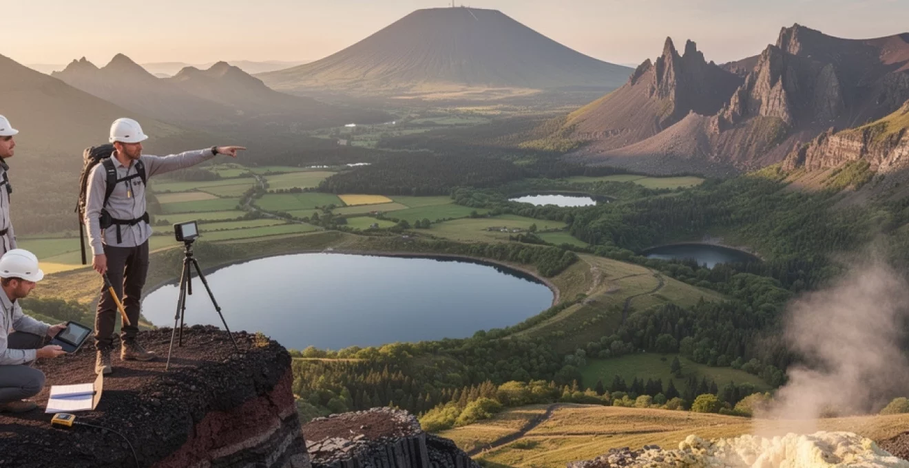
Crater lake systems including lac d’aydat and gour de tazenat
Crater lakes are among the most visually striking features of the Auvergne volcanic landscapes, and they also preserve crucial evidence of eruptive processes. Lac d’Aydat, south of Clermont-Ferrand, owes its existence to lava flows from Puy de la Vache and Puy de Lassolas, which dammed pre-existing valleys and created a natural reservoir. In this case, the lake is not a maar but a lava-dammed basin, where sediment infill and shoreline morphology reveal the history of both volcanic activity and post-eruptive erosion. Its gently sloping shores and surrounding forests make it a popular destination, but beneath the tranquil waters lies a story of fiery flows that reshaped regional drainage patterns.
Gour de Tazenat, by contrast, is a classic maar lake, formed by a violent phreatomagmatic explosion that excavated a deep, near-circular crater. The steep inner walls and almost perfectly round outline provide an ideal natural laboratory for studying maar morphology and crater-lake evolution. Sedimentary sequences on the lake floor archive not only the eruptive deposits but also thousands of years of climatic and environmental change in the Auvergne. When you walk around its rim, you can clearly see the layers of ash, lapilli, and country rock fragments that testify to the explosive interaction between magma and groundwater. Together, lakes such as Lac d’Aydat and Gour de Tazenat illustrate how different volcanic processes – lava damming and maar formation – can both generate enduring crater-lake systems.
Petrological composition and magmatic evolution
The petrological diversity of the Auvergne volcanoes reflects a long and complex magmatic evolution, from primitive basalts to evolved trachytes and phonolites. This progression is largely driven by fractional crystallisation, magma mixing, and varying degrees of crustal assimilation within the lithosphere beneath central France. Basalts erupted in the Cantal and parts of the Chaîne des Puys typically display an alkaline character, rich in sodium and potassium, indicating derivation from an enriched mantle source. In contrast, trachytes and phonolites at Puy de Dôme, Puy de Sancy, and Plomb du Cantal represent more evolved magmas that have undergone extensive differentiation in crustal magma reservoirs.
Petrographic studies under the microscope reveal mineral assemblages dominated by olivine, clinopyroxene, and plagioclase in the basalts, shifting towards sanidine, biotite, and amphibole in the more evolved rocks. Trace-element and isotopic analyses further demonstrate that some magmas interacted with older crustal rocks, acquiring distinct geochemical signatures that help geologists reconstruct magma pathways and storage conditions. For those interested in the geology of Auvergne’s volcanoes, examining hand specimens at visitor centres or along hiking trails offers a tangible way to visualise these magmatic processes – the colour, grain size, and mineral crystals you see are direct records of cooling rates, volatile content, and crystallisation history.
Across the three volcanic regions, the sequence often begins with voluminous basaltic eruptions, followed by progressively more silica-rich lavas as magmatic systems evolve. This pattern is visible in the field as a vertical and lateral transition from dark, dense lava flows to lighter-coloured, more viscous domes and intrusions. You can think of this magmatic evolution as a kind of natural distillation: as crystals form and settle out in magma chambers, the remaining melt becomes enriched in silica and incompatible elements, setting the stage for more explosive, dome-forming eruptions. This petrological framework helps explain why Auvergne offers both broad basaltic plateaux suitable for gentle hikes and steep trachytic domes that challenge even experienced walkers.
Active geothermal systems and hydrothermal activity
Although the Auvergne volcanoes are considered dormant today, the region still hosts active geothermal and hydrothermal systems that bear witness to residual heat in the crust. Thermal springs at Mont-Dore, La Bourboule, and Chaudes-Aigues, for instance, are fed by groundwater circulating deep along fault zones, where it is heated by elevated geothermal gradients before rising back to the surface. At Chaudes-Aigues in the Cantal, spring temperatures reach up to 82°C, among the hottest in Europe, and have been exploited for bathing and heating since at least the Middle Ages. These geothermal phenomena demonstrate that, even in the absence of recent eruptions, the subsurface remains thermally anomalous in parts of the Auvergne volcanic region.
Hydrothermal alteration is also evident in altered rock zones surrounding ancient conduits and along fractures within domes like Puy de Dôme. Here, hot fluids have transformed original minerals into clays, silica, and iron oxides, weakening the rock and influencing slope stability. Modern geochemical monitoring of thermal waters – measuring parameters such as temperature, pH, conductivity, and gas content – provides indirect clues about deep fluid reservoirs and potential magmatic inputs. For visitors enjoying Auvergne’s spa towns and thermal facilities, these baths are not just wellness attractions; they are the surface expression of hydrothermal systems linked to the region’s volcanic heritage.
In recent years, interest in sustainable geothermal energy has prompted studies into the potential of harnessing Auvergne’s heat for power generation and district heating. While large-scale geothermal power plants are not yet in place, pilot projects and feasibility studies underline the long-term value of this volcanic resource. When you walk through a steam-filled thermal gallery or dip your feet in a hot spring, you are interacting with energy that originated deep within Earth’s mantle, travelling upward along the same structural pathways that once fed volcanic eruptions.
Volcanic risk assessment and modern monitoring techniques
Despite their current quiescence, the Auvergne volcanoes are not considered extinct, and understanding potential future activity is an important aspect of regional risk assessment. Volcanic risk in the Auvergne is relatively low compared to active plate-boundary settings, but the presence of populated areas, transport infrastructure, and tourism hubs near dormant volcanoes means that careful monitoring remains essential. French geological and geophysical institutes maintain seismic networks, GPS stations, and satellite-based InSAR observations to detect any subtle signs of reactivation, such as small earthquakes, ground deformation, or changes in gas emissions.
Modern monitoring techniques in the Auvergne volcanic region combine multiple data streams to build a comprehensive picture of subsurface processes. Seismometers record micro-earthquakes that might signal magma movement or fault reactivation, while continuous GPS measurements track millimetre-scale ground motions that could indicate inflation or deflation of deep reservoirs. Satellite radar interferometry provides regular, high-resolution images of ground deformation over large areas, allowing scientists to detect patterns that might otherwise go unnoticed. Gas geochemistry, particularly measurements of CO2 and helium isotopes in springs and soils, offers another tool for identifying renewed magmatic degassing.
From a practical standpoint, volcanic risk assessment in Auvergne also involves land-use planning, public education, and the integration of hazard scenarios into local emergency management plans. Hiking trails, viewpoints, and visitor centres often include interpretive panels that explain both the beauty and the potential hazards of volcanic landscapes, encouraging responsible exploration. While the probability of a new eruption in the near term is considered low, the geological record reminds us that the last eruptions occurred only a few thousand years ago – a blink of an eye in geological time. By combining state-of-the-art monitoring with clear communication, authorities aim to ensure that you can safely enjoy the volcanic landscapes of Auvergne while remaining informed about the natural processes that created them.