Paris transforms into a living canvas beyond the walls of traditional galleries, where contemporary artists have claimed the urban landscape as their primary medium of expression. The French capital’s street art scene has evolved from underground rebellion to mainstream cultural phenomenon, creating distinct artistic territories across the city’s arrondissements. Each neighbourhood tells its own visual story through a diverse tapestry of murals, stencils, wheat paste installations, and collaborative works that reflect both local identity and international artistic movements.
The democratisation of public art spaces in Paris represents a significant shift in how municipal authorities approach urban aesthetics and community engagement. Street art documentation has become essential for understanding the city’s cultural evolution, as these ephemeral works often serve as historical markers of social movements, political discourse, and artistic innovation. Modern digital mapping technologies now enable real-time tracking of new installations whilst preserving records of works that may disappear due to weather, renovation, or intentional removal.
Belleville and ménilmontant street art districts: underground muralism hotspots
The northeastern districts of Belleville and Ménilmontant function as Paris’s most concentrated hubs for underground street art culture, where gentrification and artistic resistance create a dynamic tension visible on every corner. These historically working-class neighbourhoods have transformed into experimental laboratories for contemporary urban art, attracting both established international artists and emerging local talents who find affordable studio spaces and receptive community support.
The architectural landscape of these districts provides ideal conditions for large-scale murals, with numerous blank walls on residential buildings, abandoned structures, and industrial sites serving as impromptu galleries. Local resident associations have developed increasingly sophisticated relationships with street artists, often commissioning works that reflect neighbourhood identity whilst maintaining the authentic spirit of guerrilla art practices.
Rue dénoyez collaborative mural projects and artist collectives
Rue Dénoyez stands as perhaps the most concentrated display of collaborative street art in Europe, where multiple artist collectives maintain ongoing projects that evolve weekly. The street functions as an open-air workshop where painters, stencil artists, and mixed-media practitioners work alongside each other, creating layered compositions that blur individual artistic boundaries. This collaborative approach reflects broader trends in contemporary art practice, where collective creation challenges traditional notions of artistic authorship.
Artist residency programmes in the area facilitate international exchanges, bringing practitioners from diverse cultural backgrounds to contribute to the street’s ever-changing visual narrative. Community engagement initiatives ensure local residents participate in artistic decisions, preventing the displacement effects often associated with rapid cultural gentrification. Recent studies indicate that over 80% of new works on Rue Dénoyez incorporate elements suggested by neighbourhood residents.
Place Sainte-Marthe stencil art installations by local practitioners
Place Sainte-Marthe represents a more refined approach to public art integration, where local practitioners specialise in sophisticated stencil techniques that complement the square’s historic architecture. The intimate scale of this location encourages detailed work that rewards close examination, contrasting with the bold statement pieces found in larger public spaces. Artists working here often employ multiple-layer stenciling processes that create photographic-quality imagery whilst maintaining the characteristic aesthetic of street art.
The technical precision required for successful stencil art installation in this location has attracted master practitioners who use the space to demonstrate advanced techniques to younger artists. Mentorship programmes facilitated through local cultural centres ensure knowledge transfer between generations of street artists, preserving traditional methods whilst encouraging innovation in materials and application techniques.
Villa de l’ermitage hidden fresco networks and commissioned works
Villa de l’Ermitage conceals an extensive network of commissioned frescoes within its residential courtyards and building passages, accessible only to those familiar with local geography or guided by residents. These hidden works represent some of Paris’s most ambitious residential street art projects, where property owners collaborate directly with artists to create site-specific installations that enhance rather than conflict with existing architecture.
The secluded nature of these locations allows for experimental techniques and controversial subject matter that might face censorship in more visible public spaces. Artists working in Villa de l’Ermitage often spend months developing concepts in consultation with residents, resulting in works that achieve genuine
coherence between artistic vision and everyday living environments. Many of these frescoes integrate architectural features such as balconies, window frames, and stairwells, transforming functional elements into narrative devices. For visitors using a Paris street art map, Villa de l’Ermitage illustrates how contemporary muralism can operate in semi-private spaces, expanding the definition of what constitutes a public artwork.
Parc de belleville legal wall spaces and rotating artist programmes
Parc de Belleville offers a different model of urban art display through its officially designated legal walls, where artists can paint without fear of fines or removal. These sanctioned surfaces are managed through rotating artist programmes that invite both local and international practitioners to produce new work on a quarterly or even monthly basis. The result is a constantly evolving panorama of styles that range from classic graffiti lettering to photorealistic portraits and abstract compositions.
Legal wall spaces within the park are strategically positioned along pedestrian routes and stairways, ensuring high visibility while maintaining respect for surrounding residential areas. For those mapping Paris street art, Parc de Belleville functions as a reliable anchor point, guaranteeing fresh content on each visit. You can think of it as an outdoor laboratory where new techniques, colour palettes, and collaborative formats are tested before appearing elsewhere in the city.
Le marais contemporary street art galleries and outdoor exhibition spaces
Le Marais has emerged as a bridge between grassroots street practices and the institutional art world, combining independent galleries with high-density outdoor interventions. Once defined primarily by its medieval architecture and Jewish heritage, the district now hosts a robust ecosystem of contemporary urban art galleries that programme exhibitions in sync with what appears on nearby facades. This dual system turns the neighbourhood into a hybrid exhibition space where you move fluidly between curated interiors and spontaneous exterior pieces.
The compact street grid of Le Marais favours street art walking tours that cover several micro-zones within a short distance. Mapping initiatives in this area often distinguish between sanctioned murals, tolerated paste-ups, and fully illegal graffiti, allowing researchers and visitors to understand how regulation shapes the visual landscape. As property owners increasingly commission bespoke works, questions around conservation, authenticity, and commercialisation become central to any serious documentation of the district.
Rue des rosiers wheat paste installations and paper-based artworks
Rue des Rosiers functions as a corridor for wheat paste installations and paper-based artworks that can be updated quickly in response to current events. These lightweight interventions are particularly well suited to the narrow facades and shopfront shutters of the street, where permanent painting would face stricter regulatory controls. Artists favour paste-ups here because they can layer multiple images, texts, and textures, turning even a single door into a stratified archive of urban communication.
From a mapping perspective, Rue des Rosiers highlights one of the core challenges of Paris street art documentation: how do you record artworks with a life span of only a few days? Digital photographers and app-based mappers often revisit this street several times per month, capturing temporal sequences that show how a particular wall mutates over time. For you as a visitor, this means that returning to the same spot can feel like reloading a website that has updated its content overnight.
Place des vosges periphery: sanctioned mural commissions
While the historic core of Place des Vosges remains heavily protected, its periphery has become a testing ground for sanctioned mural commissions that respect strict heritage guidelines. Here, artists work closely with architects and preservation authorities to develop designs that enhance rather than overpower the classical symmetry of the square. Colour palettes tend toward muted tones, and compositions frequently echo the arches, pilasters, and cornices of nearby façades.
These projects demonstrate how large-scale street art in Paris can coexist with centuries-old architecture without resorting to pastiche. Mapping teams often categorise them separately from more spontaneous graffiti, classifying them as heritage-compatible murals. If you are planning a route with a Paris street art map, the Place des Vosges periphery is ideal when you want to combine art hunting with a more traditional architectural stroll.
Rue vieille du temple gallery spillover and authorised exterior pieces
Rue Vieille du Temple illustrates the phenomenon of gallery spillover, where works created or sold in commercial spaces inspire authorised pieces on the buildings that host them. Many galleries in this area negotiate with landlords for limited exterior interventions—small murals, sculptural additions, or text-based works—that act as visual signposts for their curatorial identity. These pieces are usually documented as part of both gallery catalogues and independent street art maps, blurring the line between institutional and informal networks.
For the casual observer, the street appears as a continuous flow of visual culture, with window displays, interior exhibitions, and exterior walls all contributing to a single narrative. Researchers studying Paris street art mapping have noted that Rue Vieille du Temple generates a high density of geo-tagged images on social media platforms, making it one of the most digitally visible corridors in Le Marais. When you walk here, you are not just seeing art—you are entering a feedback loop where each photograph you take feeds back into the area’s global online profile.
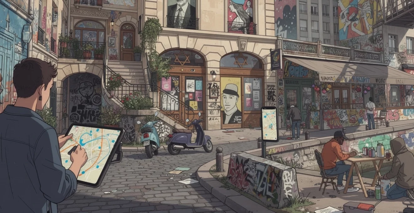
Jewish quarter historical building integration techniques
The Jewish Quarter within Le Marais presents specific constraints and opportunities for street artists due to its concentration of listed buildings and memorial sites. Integration techniques here prioritise reversibility and subtlety: removable panels, light projections, and temporary banners are preferred over direct painting on historic stonework. Artists often design works that respond to existing signage, security shutters, and ventilation grilles, using them as compositional anchors rather than obstacles.
These methods offer a valuable case study for anyone interested in how street art in Paris negotiates with strict heritage regulation. Cartographers specialising in urban art frequently annotate their maps with information about building protection status, helping users understand why certain streets host dense interventions while others remain visually untouched. As you navigate the Jewish Quarter, you will notice that the most impactful pieces often occupy liminal spaces—alleyway entrances, service doors, and temporary hoardings surrounding restoration works.
13th arrondissement industrial canvas: large-scale mural documentation
The 13th arrondissement has become Paris’s flagship district for monumental murals, turning former industrial corridors into a curated open-air museum. Tower blocks along Boulevard Vincent-Auriol, Avenue de France, and adjacent streets serve as vertical canvases for internationally renowned artists such as Shepard Fairey, INTI, Obey, D*Face, and Vhils. Municipal partnerships with galleries like Itinerrance have led to more than 50 large-scale works being installed since the early 2010s, with new commissions announced almost every year.
Documenting these pieces presents unique methodological challenges due to their height and scale. Professional mappers often use drones, long-lens photography, and elevation diagrams to capture complete compositions that are impossible to see from a single ground-level vantage point. For visitors relying on a Paris street art map, the 13th offers one major advantage: many “hero walls” are aligned along clear boulevards, allowing you to structure a straightforward walking route that takes in a high concentration of murals without complex navigation.
Smaller neighbourhoods within the arrondissement, such as Butte-aux-Cailles, provide an important counterpoint to the mega-mural aesthetic. Here, you will find dense networks of stencils, paste-ups, and mid-size frescoes by artists like Seth, Miss.Tic, and C215, often tucked into side streets and stairways. Mapping tools frequently differentiate between the boulevard-scale works and these more intimate interventions, giving users the choice between a “skyline tour” and a ground-level exploration. Whichever route you choose, the 13th arrondissement exemplifies how urban planning and street art policy can transform a once peripheral district into a key destination.
Oberkampf and république underground scene mapping methodologies
The Oberkampf and République areas are synonymous with the city’s underground street art scene, where legal projects and unsanctioned interventions coexist in a dense urban grid. Iconic initiatives such as Le M.U.R. Oberkampf—where a new curated piece appears every few weeks—provide an official framework that cohabits with nearby tags, throw-ups, and experimental works. This layered environment makes the district a prime testing ground for new mapping methodologies aimed at capturing both permanence and flux.
Researchers and enthusiasts in this zone often employ time-based mapping, recording not just the location of a mural but also its installation and removal dates. Some projects resemble a visual diary of the neighbourhood, updating a digital Paris street art map after each repaint of Le M.U.R. or each major graffiti jam on side streets. Have you ever wished you could rewind a wall to see what was there last month? Animated map timelines developed for Oberkampf and République come close to providing that experience.
Data collection in this area also experiments with community-sourced verification. Local residents, bar owners, and regular visitors use dedicated apps or private messaging groups to alert mappers when new works appear or existing ones are buffed. This crowdsourced approach mirrors the way open-source software is maintained: many contributors perform small updates that keep the overall system accurate. For you as a user, it means that a well-maintained Oberkampf street art map is often the most up-to-date document of the neighbourhood’s creative pulse.
Seine riverbank legal graffiti zones and temporary installation permits
The Seine riverbanks provide some of Paris’s most visible legal graffiti zones, especially in converted infrastructure such as the Tunnel des Tuileries. Once reserved for vehicular traffic, this tunnel now operates as a covered promenade lined with rapidly rotating pieces by graffiti writers and muralists from across Europe. City authorities manage the space through a combination of tacit tolerance and periodic clean-ups, creating an informal but stable environment where artistic experimentation can flourish.
In addition to permanent legal zones, the riverbanks are increasingly used for temporary installations authorised through short-term permits. These might include large-scale sculptures, light projections, or floating interventions moored along the quais during festivals and cultural events. From a mapping perspective, these works challenge the notion of fixed coordinates: a boat-mounted mural or a projection on moving water requires not just a point on a Paris street art map but also a time window when the piece is active.
For visitors, the Seine offers an ideal setting to combine art exploration with classic sightseeing. You might, for example, walk from the Louvre towards the Eiffel Tower while passing through multiple graffiti clusters that sit just below the tourist eye-line of the main embankment. This contrast between postcard views and subcultural zones illustrates one of Paris’s defining characteristics: high culture and underground practices often occupy the same physical space, separated only by a few metres of elevation.
Digital street art navigation tools and geolocation tracking systems
The rapid evolution of the Paris street art scene has driven parallel innovations in digital navigation tools and geolocation tracking systems. Traditional printed maps have largely given way to interactive platforms that allow you to filter works by artist, medium, date, or district. Many of these tools integrate with GPS, guiding you from one mural to the next in real time while also suggesting nearby cafés, bookshops, and galleries that align with an alternative, creative itinerary.
At a technical level, contemporary mapping projects rely on a mixture of manual input and automated data collection. Geo-tagged photographs harvested from social media, for example, can be cross-referenced with known coordinates to identify new works or confirm changes to existing ones. Some research-oriented platforms anonymise user data but retain movement patterns, revealing how people actually traverse neighbourhoods when following a street art route. This behavioural layer is invaluable for urban planners considering where to allocate new legal walls or cultural funding.
Of course, digital tools are only as useful as the information they contain. Many curators and bloggers recommend a hybrid approach: use a reliable Paris street art map as your backbone, but remain open to detours whenever you glimpse colour down a side street. Think of the map as a compass rather than a script—it points you in promising directions without dictating every step. In the same way that street art itself balances planning and spontaneity, the most rewarding explorations come when you let real-time discovery and geolocation technology work together.