# Exploring the Wild Beauty of the Camargue
Nestled between the two arms of the Rhône Delta in southern France lies a landscape so distinctive it feels otherworldly. The Camargue defies expectations of what Provence should look like, trading lavender fields and hillside villages for vast salt marshes, pink-hued lagoons, and horizons so flat they seem to stretch into infinity. This wetland wilderness, covering over 100,000 hectares, represents one of Western Europe’s most significant ecosystems—a place where Mediterranean meets marsh, and where wildlife thrives in conditions that would challenge most species. For nature enthusiasts, photographers, and those seeking authentic outdoor experiences away from the crowded Riviera, the Camargue offers something genuinely rare: a corner of France that remains stubbornly, beautifully wild.
Geographic characteristics and ecosystems of the rhône delta wetlands
The Camargue’s geographical formation is the result of millennia of sediment deposition by the Rhône River as it splits into two distributaries—the Grand Rhône and the Petit Rhône—before emptying into the Mediterranean Sea. This dynamic process has created a mosaic of habitats that shift with the seasons, ranging from freshwater marshes in the north to hypersaline lagoons in the south. The region’s flat topography, with elevations rarely exceeding five metres above sea level, makes it particularly susceptible to both river flooding and marine incursion, creating the brackish conditions that define much of the landscape.
The transition zones between fresh and saltwater environments support remarkably diverse biological communities. These ecotones harbour species adapted to fluctuating salinity levels, from salt-tolerant plants like Salicornia and Arthrocnemum to aquatic invertebrates that form the foundation of the wetland food web. The delicate balance between terrestrial and aquatic ecosystems means that even slight changes in water management or climate patterns can have cascading effects throughout the entire regional ecosystem.
Étang de vaccarès: the largest lagoon and its brackish water biodiversity
At the heart of the Camargue lies the Étang de Vaccarès, a vast brackish lagoon spanning approximately 6,500 hectares. This shallow body of water, with depths rarely exceeding two metres, serves as the ecological centrepiece of the region. Its salinity fluctuates seasonally depending on rainfall, evaporation rates, and the degree of connection to the sea, creating conditions that support both freshwater and marine species. In winter, when rainfall is highest, thousands of waterfowl congregate here, taking advantage of the abundant food resources.
The lagoon’s mudflats and shallow waters provide critical feeding grounds for wading birds during migration periods. Species such as avocets, black-winged stilts, and various sandpiper species probe the nutrient-rich sediments for invertebrates. The lagoon’s periphery, where reed beds meet open water, offers nesting habitat for herons, egrets, and marsh harriers. This productivity stems from the constant input of organic matter from surrounding marshes and the mixing of nutrient-laden freshwater with the sea.
Salt marsh formations and halophytic vegetation communities
The Camargue’s salt marshes represent some of Europe’s most extensive halophytic plant communities. These areas, known locally as sansouïres, are characterised by succulent perennial plants that have evolved remarkable adaptations to cope with high soil salinity. Glassworts, sea lavender, and sea purslane dominate these harsh environments, their fleshy leaves storing water and excreting excess salt through specialised glands. The vegetation appears almost lunar in its sparseness, with individual plants scattered across cracked, salt-encrusted soil.
These salt steppes play a crucial ecological role beyond their botanical significance. They buffer inland areas from storm surges, filter pollutants from agricultural runoff, and provide grazing for the Camargue’s famous horses and bulls. The seasonal colour changes—from green in spring to purple and red in autumn as plants accumulate pigments in response to salt stress—create landscapes that photographers find endlessly compelling. Walking through these areas
reveals just how finely tuned life here is to salt and seasonal water. Underfoot, the ground can feel almost like baked pottery after a long dry spell, then soften into slick mud following autumn rains. For visitors, staying on marked paths is essential, both to avoid damaging fragile root systems and to keep your shoes from becoming irretrievably caked in clay. If you’re interested in plant ecology, bring a field guide: you’ll quickly realise that what first appears barren is, in fact, a rich patchwork of specialised halophytic vegetation.
Dune systems along the mediterranean coastline at plage de piémanson
Where the Rhône Delta meets the open Mediterranean, the landscape shifts again into a sequence of sandy beaches and mobile dune systems. Plage de Piémanson, near Salin-de-Giraud, is one of the most striking examples—a long, windswept strand backed by low, shifting dunes. These dunes are sculpted constantly by the Mistral wind and wave action, making them one of the most dynamic features of the Camargue’s coastal geomorphology. Here, the boundary between land and sea is anything but fixed.
Despite their apparent fragility, the dunes host a resilient community of pioneer plants that help stabilise the sand. Species such as marram grass and sea holly send deep root systems into the dunes, trapping sediments and reducing erosion in much the same way rebar reinforces concrete. This vegetation not only preserves the coastline but also provides habitat for invertebrates and ground-nesting birds. When you walk along Piémanson’s shore, you’re moving through a living barrier that shields the inland salt ponds and rice fields from storm surges and sea-level rise.
Visitor pressure can pose a real threat to these dune ecosystems, especially during the peak summer season. To protect them, access is increasingly channelled along designated paths, and vehicles are kept away from the most sensitive areas. If you’re planning a beach day here, opting to park back from the shoreline and approaching on foot is both more sustainable and often more enjoyable. You’ll have time to appreciate the subtle gradation from sandy beach to embryonic dune to established shrub, and to notice how each band of vegetation marks a different level of exposure to wind and salt spray.
Seasonal flooding patterns and sansouïre landscape dynamics
One of the defining characteristics of the Camargue is its seasonal rhythm of flooding and drying. Winter and early spring typically bring higher river flows and rainfall, allowing fresh water to spread across the plains and recharge marshes and temporary pools. By late spring and summer, evaporation and controlled drainage concentrate salts at the surface, transforming large expanses into the shimmering sansouïre landscape. This annual hydrological pulse governs everything from plant germination to bird migration timing.
The sansouïres themselves—those low-lying salty steppes—are in constant flux. After winter inundation, new growth appears in carpets of low halophytes, feeding grazing animals and invertebrates. As the soil dries and salt crystals begin to form, colours intensify and species composition shifts toward the most salt-tolerant plants. Think of it as a natural kaleidoscope: tilt the balance slightly toward fresh water or salt and the pattern of life you see changes dramatically. For land managers, predicting and guiding these changes through sluice gates and canals is a delicate art.
For visitors, the season you choose will shape your experience of the Rhône Delta wetlands. In spring and autumn, when water levels are intermediate and temperatures mild, walking and cycling routes offer close-up views of flooded meadows, shallow pools, and feeding flocks of birds. In high summer, the landscape looks more austere, with cracked earth and mirage-like heat ripples, but this is also when the sansouïres glow with reds and purples at sunset. Whichever period you choose, it’s wise to check local information about accessible trails, as some tracks may be temporarily closed due to high water or conservation work.
Ornithological significance: greater flamingo colonies and migratory bird routes
The Camargue’s wetlands are not only visually dramatic; they are also of immense ornithological importance. Situated on a key junction of the Western Palearctic-African flyway, the Rhône Delta functions like an international airport for birds moving between Europe and Africa. Over 400 species have been recorded here, and at peak migration times in spring and autumn, hundreds of thousands of individuals pass through or stop to refuel. Among them, the greater flamingo—Phoenicopterus roseus—has become the emblem of the region, its pink plumage mirrored in the rose-tinted salt ponds.
What makes birdwatching in the Camargue particularly rewarding is the proximity you can achieve without disturbing wildlife. Carefully designed observation hides, raised boardwalks, and clearly marked viewing areas allow you to witness natural behaviours at close range. Whether you’re a seasoned birder with a spotting scope or a curious traveller armed only with a smartphone, you’ll find opportunities to observe both common and rare species. Just remember that in this living sanctuary, patience is often rewarded: staying quiet and still for a few extra minutes can turn a distant silhouette into a memorable encounter.
Phoenicopterus roseus breeding grounds and nesting behaviour
The Camargue hosts the only regular breeding colony of greater flamingos in France and one of the most important in the Mediterranean. The main site, centred on Étang du Fangassier, offers the mix of shallow, saline water and isolation that these birds require to nest successfully. Flamingos build conical mud nests, sometimes over 30 centimetres high, which rise above the water level and protect eggs from minor fluctuations in depth. From a distance, the colony can resemble a low, pale city rising out of the lagoon, populated by thousands of elegant residents.
Nesting usually begins in late winter or early spring, with courtship displays that are as striking as any dance performance. Groups of birds march in synchrony, turning their heads from side to side and stretching their wings to reveal bands of vivid pink and black. Once eggs are laid—typically one per nest—both parents share incubation duties for about four weeks. After hatching, the chicks, initially grey and fluffy, form crèches and are guarded collectively, a strategy that helps deter predators. For conservationists, maintaining stable water levels and minimising human disturbance during this sensitive period is critical.
Visitors cannot approach the main breeding islands for obvious reasons, but there are several vantage points and interpretation centres where you can learn about flamingo behaviour and observe them without stress. Binoculars or a zoom lens will make a big difference here. If you’ve ever wondered how flamingos gain their characteristic colour, the Camargue provides a live answer: their pink hues come from carotenoid pigments in the tiny crustaceans and algae they filter from the water, which are particularly abundant in these saline lagoons. Watching them sieve the water with their uniquely adapted beaks adds another fascinating layer to any wetland visit.
Western Palearctic-African flyway: wader and waterfowl migration corridors
Beyond flamingos, the Camargue is a crucial milestone on the long journey many birds make between northern Europe and sub-Saharan Africa. This migration route, known as the Western Palearctic-African flyway, channels enormous numbers of waders and waterfowl through the Rhône Delta each year. Species such as curlew sandpipers, dunlins, ruffs, and black-tailed godwits rely on the region’s mudflats as refuelling stations, probing the sediments for worms and small crustaceans. For them, a few undisturbed days of feeding can mean the difference between a successful migration and exhaustion.
Waterfowl, including teal, pintail, shovelers, and greylag geese, also take advantage of the Camargue’s mosaic of open water, rice fields, and flooded meadows. In winter, aerial counts conducted by conservation organisations regularly record tens of thousands of ducks spread across Étang de Vaccarès and surrounding marshes. Think of these wetlands as a vast, seasonal buffet: as water levels rise and fall, different feeding niches open up, catering to a wide variety of bills and foraging strategies. Coordinated management ensures that some areas remain flooded or partially drained at key times to support this avian traffic.
If you’re planning a bird-focused trip, timing is everything. Spring (March to May) and autumn (September to November) offer the richest diversity, with both resident species and migrants present. Several local nature centres provide up-to-date information on sightings and recommended viewing spots, which can be invaluable when you’re trying to decide whether to head for the rice fields, the coastal lagoons, or the reed beds. And if the idea of identifying dozens of waders feels daunting, consider joining a guided excursion; having an expert at your side can turn a confusing blur of grey birds into a compelling story of global migration.
Purple heron and squacco heron habitats in reed bed ecosystems
Reed beds are another key habitat within the Camargue, forming dense, rustling belts along the edges of lagoons, canals, and shallow lakes. Dominated by common reed (Phragmites australis), these zones provide both cover and nesting sites for a host of specialised birds. Among the most emblematic are the purple heron (Ardea purpurea) and squacco heron (Ardeola ralloides), two species that are far easier to hear or glimpse briefly than to see well. Their reliance on secluded, well-developed reed beds makes them excellent indicators of wetland health.
Purple herons are taller and more secretive than their grey cousins, favouring quiet, flooded reed beds where they stalk fish, amphibians, and insects. Their nests—platforms of reeds and stems—are often hidden deep within dense stands, accessible only by narrow water channels. Squacco herons, smaller and more compact, specialise in ambush hunting from low perches near the water’s edge. In breeding plumage, their buff and white feathers with pale blue bills are surprisingly striking at close range, yet they blend almost perfectly into the dry reeds from a distance, like ghosts of the marsh.
To observe these herons, patience and careful positioning are essential. Early morning and late afternoon, when light is softer and birds are most active, offer the best chances. Many reserves have discreet observation huts overlooking reed-fringed pools where you can sit quietly and let the wildlife come into view. As you watch, you’ll notice how the reed bed functions much like a city of vertical streets: warblers flit through the upper layers, bitterns boom invisibly from the depths, and herons commute between feeding grounds and colony sites. Appreciating this vertical complexity will deepen your understanding of why intact reeds are so important in the Camargue.
Raptor species: short-toed snake eagle and marsh harrier populations
Look up on a clear day over the Camargue and chances are you’ll spot one of its resident raptors patrolling the skies. Among the most notable are the short-toed snake eagle (Circatus gallicus) and the western marsh harrier (Circus aeruginosus), both of which have healthy breeding populations here. Their presence adds a dramatic, aerial dimension to the wetland ecosystem, and they play a vital role in controlling populations of reptiles, small mammals, and other birds. For many visitors, seeing one of these birds of prey perform a hunting dive is a highlight of their time in the Rhône Delta wetlands.
The short-toed snake eagle is a specialist, feeding primarily on snakes and large lizards. It favours open areas interspersed with scrub where it can scan the ground from a high vantage point, then glide down in controlled, powerful stoops. In contrast, marsh harriers are masters of low, buoyant flight over reed beds and marshes. They quarter back and forth just above the vegetation, ready to drop suddenly onto unsuspecting prey. Watching a harrier weave over a golden reed bed at sunset is like watching a slow-motion, three-dimensional tapestry in motion.
From a conservation perspective, raptors are often considered top-level indicators of ecosystem integrity. Stable or increasing populations of marsh harriers and short-toed snake eagles suggest that prey species and habitats remain sufficiently abundant and undisturbed. For travellers interested in raptor watching, bringing a pair of binoculars with good light-gathering capacity is essential, as many observations take place against bright skies or at long range. Position yourself along edges where fields meet wetlands, or near large reed-fringed lagoons, and scan regularly; with a bit of practice, you’ll begin to recognise each species by its distinctive flight silhouette.
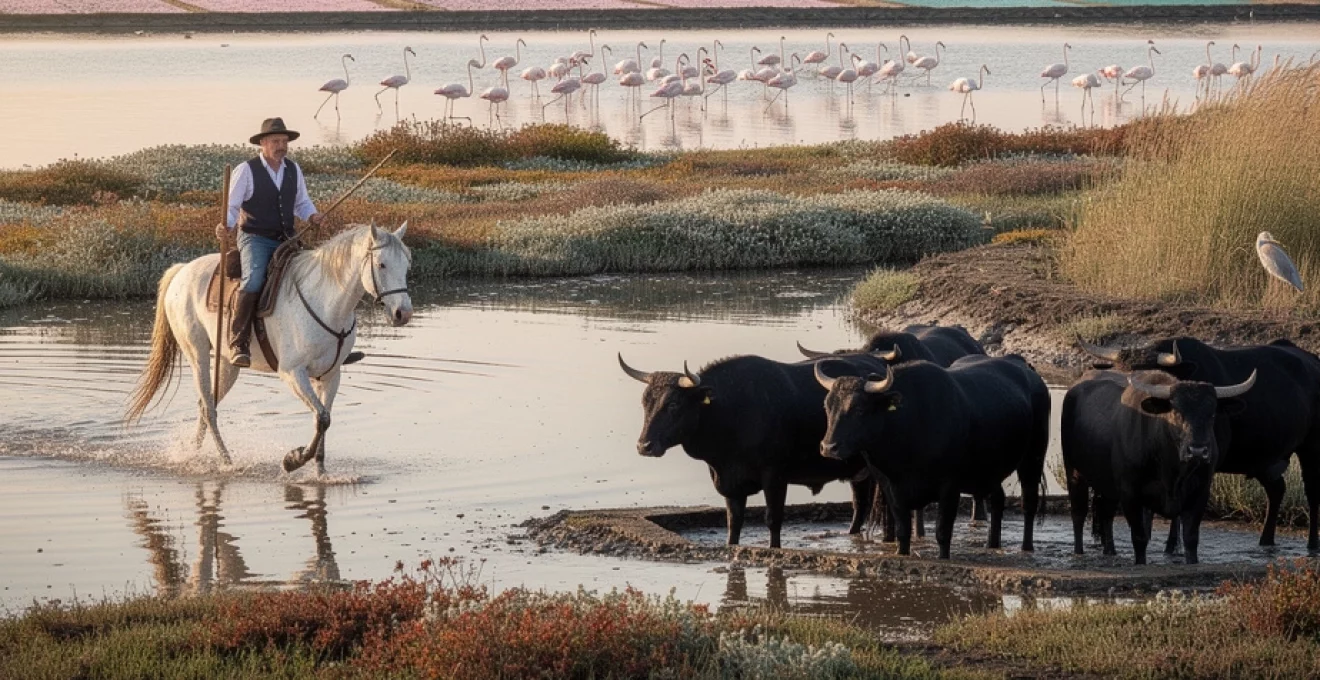
Endemic camargue horse and black bull traditional breeding practices
Beyond its birds and wetlands, the Camargue is deeply shaped by its pastoral traditions, especially the breeding of its iconic white horses and black bulls. These animals are not just picturesque extras in a Mediterranean landscape; they are central to the region’s cultural identity and land management. Over centuries, local herders have developed husbandry systems adapted to the harsh, saline environment, creating a form of agriculture that is as much about maintaining open habitats as it is about producing meat or livestock. When you see a herd silhouetted against a sunset, you’re witnessing a living link between ecology and heritage.
These traditional breeding practices have helped preserve semi-natural grasslands and sansouïres that might otherwise have been converted to intensive agriculture or abandoned altogether. Grazing by horses and bulls keeps woody plants in check, preventing the encroachment of shrubs into open wetlands and maintaining feeding areas for wading birds. At the same time, the image of white horses galloping through shallow water and black bulls standing knee-deep in reeds has become inseparable from the way many people imagine the Camargue. For visitors, understanding how these animals are bred and managed offers a richer, more nuanced view than that provided by a simple photo stop.
Equus caballus camargue: ancient breed characteristics and hardy adaptations
The Camargue horse, often referred to simply as the “Camargue,” is one of the oldest horse breeds in the world, with roots that may stretch back to prehistoric times. Officially recognised as a distinct breed in the 1970s, it is renowned for its compact build, strong legs, and exceptional hardiness. Foals are born a dark colour—brown or black—and slowly lighten with age to the pale grey or white that most visitors associate with the region. This gradual transformation adds an almost mythical quality to the breed’s life cycle.
Adapted to life in saline marshes and fluctuating water levels, Camargue horses have tough hooves that resist softening and rotting in wet substrates. Their metabolic efficiency allows them to thrive on relatively poor, rough forage, an essential trait in a landscape where lush grass is seasonal at best. Think of them as the all-terrain vehicles of the equine world: small enough to be agile in tight, muddy environments, yet strong enough to carry riders for long days of work. Behaviourally, they are known for their calm, steady temperament, which makes them particularly suitable for novice riders and guided treks across the wetlands.
For travellers who dream of riding through the Camargue’s lagoons and beaches, many local stables and manades (ranches) offer excursions on well-trained Camargue horses. Sessions range from short introductory rides of an hour or two to full-day outings that combine marsh, beach, and sansouïre landscapes. Basic safety gear, such as helmets, is typically provided, and prior riding experience is not always required. When choosing an operator, consider asking about herd management and welfare practices; responsible tourism helps ensure that this ancient breed continues to flourish in its native habitat.
Manade management systems: guardian culture and livestock husbandry
Central to the Camargue’s pastoral life are the manades, traditional ranches where horses and bulls are raised in semi-liberty. These operations are overseen by gardians, the Camargue’s equivalent of cowboys, who patrol their herds on horseback. Unlike intensive feedlot systems, manade management relies on extensive grazing across large, unfenced or lightly fenced tracts of land. Animals move with the seasons, seeking fresh forage and higher ground as water levels change, much as they would in a wild setting but under the watchful eye of their human guardians.
The gardian culture has developed its own tools, clothing, and rituals over centuries. Traditional attire includes a broad-brimmed hat, embroidered waistcoat, and sturdy boots suitable for marshy ground, while the distinctive, trident-tipped trident camarguais is used to guide and separate animals. Herding techniques favour calm, controlled movements rather than high-speed chases, reflecting a deep familiarity with animal behaviour. You might compare the relationship between gardians and their herds to that of experienced sailors and the sea: respectful, attentive, and honed by countless hours in the field.
Many manades now welcome visitors for guided tours, demonstrations, and even meals featuring local specialities. These experiences can offer valuable insights into sustainable livestock husbandry in a sensitive wetland environment. When you join a visit, you’ll often see how water levels, vegetation patterns, and herd rotations are coordinated to maintain both animal health and habitat diversity. It’s a vivid example of how traditional knowledge and modern conservation goals can align when managed thoughtfully.
Course camarguaise: raseteur traditions and bull-running spectacles
While Camargue bulls are raised primarily for meat and breeding, they also play a starring role in a distinctive local spectacle known as the Course Camarguaise. Unlike Spanish bullfighting, this is a bloodless sport in which the bull is not killed. Instead, agile young men called raseteurs attempt to snatch a small rosette or tassel attached between the animal’s horns. Armed only with a hooked comb and protected by light padding, they dart in and out of the bull’s path, relying on speed and timing rather than brute strength.
The bulls, for their part, are selected for athleticism and character, and the most celebrated animals can enjoy long careers, appearing in multiple festivals and accumulating a devoted following. In many ways, the bull is the true star of the show, with its name prominently announced and cheered by the crowd. Some individuals become local legends, remembered for their agility and determination. After the event, they return to their pastures rather than the slaughterhouse, a fact that many animal welfare advocates cite as a key difference from other forms of bull spectacle.
Attending a Course Camarguaise in a village arena, such as those in Saintes-Maries-de-la-Mer or Arles, offers a window into the social fabric of the region. Music, food, and community pride all play their part, turning race days into full-fledged celebrations. If you’re curious but concerned about animal treatment, doing a bit of research beforehand can help you decide whether to attend. Observing one of these events, even from the stands, adds context to the black bulls you see grazing in the wetlands and highlights how deeply intertwined they are with Camargue identity.
Protected areas and conservation frameworks within the biosphere reserve
Given its ecological richness and cultural significance, it’s no surprise that the Camargue is subject to a complex web of conservation designations. At the heart of this framework lies its status as a UNESCO Biosphere Reserve, complemented by regional, national, and international protections. Together, these layers aim to safeguard habitats, species, and traditional ways of life while still allowing for carefully managed tourism and agriculture. Understanding how these designations work will help you appreciate why some areas are freely accessible while others are strictly off-limits.
Rather than functioning as a single, locked-down reserve, the Camargue’s protected areas are organised into zones with varying degrees of restriction. Core areas are set aside for conservation and scientific monitoring, buffer zones accommodate low-impact activities, and transition areas permit a wider range of human uses. Think of it as concentric rings of protection: the closer you get to the ecological core, the tighter the rules become. For visitors, respecting these boundaries—staying on marked trails, observing signage, and following local guidance—is a simple but powerful way to contribute to long-term preservation.
Parc naturel régional de camargue: UNESCO MAB programme designation
The Parc Naturel Régional de Camargue, created in 1970, covers a large portion of the Rhône Delta between the two main arms of the river. In 1977, it was recognised under UNESCO’s Man and the Biosphere (MAB) Programme, which promotes models of sustainable development that integrate conservation with local livelihoods. This dual status—regional natural park and biosphere reserve—reflects the Camargue’s role as both a living landscape and a scientific laboratory for understanding how people and wetlands can coexist.
Within the park’s boundaries, management priorities include maintaining water quality, controlling invasive species, supporting traditional grazing, and regulating tourism flows. A charter, renewed periodically in consultation with local stakeholders, sets out shared objectives for municipalities, farmers, fishers, and business owners. For example, measures to reduce pesticide runoff from rice fields not only benefit birds and aquatic life but also enhance the appeal of the region for eco-conscious travellers. In this way, the park functions as a platform where environmental and economic interests are negotiated.
As a visitor, you’ll encounter the park’s presence in various subtle ways: interpretive panels at viewpoints, signposted walking circuits, educational centres, and guided outings run in partnership with local associations. If you’re interested in the UNESCO dimension, many information points explain the biosphere reserve concept and highlight ongoing research projects. By choosing services and products that carry the park’s endorsement, you support businesses that have committed to its sustainability goals—an easy way to make your trip to the Camargue more responsible.
Réserve nationale de camargue: strict protection zones and access regulations
Embedded within the broader regional park is the Réserve Naturelle Nationale de Camargue, one of France’s oldest and most strictly protected nature reserves. Established in 1927 and later expanded, it encompasses key habitats around Étang de Vaccarès and adjacent wetlands. Here, conservation takes precedence over all other uses, with regulations designed to minimise disturbance to breeding birds, sensitive vegetation, and fragile soil structures. Public access is either heavily restricted or prohibited in core zones, particularly during critical periods such as nesting season.
For scientists, the reserve serves as an invaluable reference site where long-term ecological processes can be studied with minimal human interference. Monitoring programmes track everything from water chemistry and plankton communities to bird populations and vegetation dynamics. These data help inform management decisions across the wider Camargue and contribute to international research on wetland resilience and climate change. You might think of the reserve as the region’s “control group,” against which more heavily used areas can be compared.
Although you can’t wander freely through the strictest parts of the reserve, several peripheral trails, observation points, and visitor centres offer views into these protected landscapes. Guided tours, when available, are often led by naturalists who can explain the reserve’s zoning system and share insights from current studies. It’s important to remember that the absence of access in some places is intentional and beneficial; by concentrating human presence elsewhere, these core sanctuaries remain undisturbed havens for wildlife.
RAMSAR convention implementation for wetland preservation
On the international stage, the Camargue is also recognised under the Ramsar Convention, a global treaty dedicated to the conservation and wise use of wetlands. The Rhône Delta was one of the first French sites to be listed as a Ramsar Wetland of International Importance, underscoring its value for migratory waterbirds and rare habitats. Ramsar status doesn’t create a new layer of law on the ground, but it does commit national and local authorities to maintaining the ecological character of the site over the long term.
In practical terms, Ramsar implementation in the Camargue translates into integrated water management plans, habitat restoration projects, and ongoing collaboration between government bodies, NGOs, and private landowners. For instance, re-establishing natural flood regimes in certain areas or removing obsolete dykes can improve habitat quality for fish and birds while also boosting the wetlands’ capacity to buffer floods. These efforts align with broader European Union directives on birds, habitats, and water, making the Camargue a focal point of regional conservation policy.
For travellers, seeing the Ramsar logo on information boards or brochures is a reminder that you’re visiting a site of global significance, not just local beauty. If you’re curious about how wetland preservation is evolving in a changing climate, many visitor centres provide explanations of current challenges, such as sea-level rise, salinisation, and shifting migration patterns. By learning about these issues on the ground, you’ll gain a deeper appreciation of why wetland conservation matters—not only for flamingos and herons, but also for coastal protection, carbon storage, and human well-being.
Salin-de-giraud salt production and industrial heritage landscapes
On the eastern side of the Camargue, near the mouth of the Grand Rhône, the village of Salin-de-Giraud offers a different perspective on the region’s relationship with salt and water. Here, vast salt pans stretch toward the horizon, shimmering in shades of white, mauve, and pink depending on the season and light. Industrial salt production began in the late 19th century, transforming previously undeveloped marsh into a carefully engineered mosaic of evaporation basins, dykes, and canals. Today, the site still produces around a million tonnes of salt annually, much of it destined for industrial uses.
Walking or cycling along the designated routes through the salt works feels a little like entering a science-fiction landscape. Crusts of crystallised salt form on the ground, crackling underfoot like thin ice, while piles of harvested “white gold” rise in geometric mounds that echo distant mountain ranges. The surreal pink colour of some basins comes from microalgae such as Dunaliella salina, which thrive in hypersaline conditions and produce carotenoid pigments to protect themselves from intense sunlight. These same algae help feed brine shrimp, which in turn contribute to the diet of flamingos—an elegant illustration of how industrial and natural systems interlock here.
Salin-de-Giraud itself retains traces of its industrial heritage in the form of workers’ housing, old factory buildings, and community structures built to support the salt workforce. The village layout, with its neat rows of modest brick houses and gardens, contrasts with the scattered, whitewashed architecture of Saintes-Maries-de-la-Mer on the opposite side of the delta. Exploring its streets and small squares offers a glimpse into a chapter of Camargue history shaped more by industry than by agriculture or fishing. It’s an ideal stop if you’re interested in how human labour has reshaped the wetlands over the past century and a half.
From Salin-de-Giraud, a coastal road leads to wild beaches such as Plage de Piémanson and Plage de Beauduc, where dune systems and salt marshes meet the sea in dramatic fashion. Renting a bicycle in the village and following the signposted trails is one of the best ways to experience this transition from industrial landscape to near-wilderness. Do keep in mind that shade is scarce and distances can be deceptive on such flat terrain, so carrying sufficient water, sun protection, and a map or GPS is essential. As you travel, you’ll move through a living palimpsest where layers of natural and human history are written into every canal, dyke, and shimmering pond.
Photographic opportunities: capturing light dynamics across marsh territories
For photographers, the Camargue is a playground of light, texture, and movement. The combination of flat horizons, reflective water surfaces, and ever-changing skies creates conditions where subtle shifts in weather or time of day can transform a scene completely. Whether you’re using a professional DSLR or a smartphone, you’ll quickly notice how sunrise and sunset ignite the salt ponds, how midday haze softens distant reeds, and how storm clouds lend drama to otherwise minimalist vistas. In such a landscape, mastering light becomes even more important than finding subjects—though those, too, abound.
Because so much of the terrain is open and uncluttered, composition in the Camargue often revolves around the careful placement of a few key elements: a flock of flamingos, a line of reeds, a solitary horse, or a fence cutting across a flooded field. This simplicity can be liberating but also challenging; with fewer distractions, technical and artistic choices become more obvious. Asking yourself what story you want to tell—about wildness, solitude, movement, or tradition—will help guide your framing, lens selection, and choice of shooting location. And don’t forget that sometimes the most evocative images arise from less obvious subjects, such as patterns in dried mud or reflections of clouds in a rain-filled track.
Golden hour conditions at étang du fangassier flamingo viewpoints
Étang du Fangassier, one of the key sites for greater flamingos, is particularly renowned among photographers for its golden hour light. In the early morning and late afternoon, the low sun casts warm tones across the shallow water, intensifying the pink of the birds and the soft blues and mauves of the surrounding salt pans. When the air is still, reflections double the effect, creating almost symmetrical compositions that feel more like paintings than photographs. It’s no coincidence that many of the most iconic images of the Camargue’s flamingos are captured at these times.
To make the most of golden hour, planning is crucial. Checking sunrise and sunset times, as well as the weather forecast, will help you decide which side of the lagoon to position yourself on for optimal backlighting or side lighting. A telephoto lens in the 300–400 mm range is ideal for isolating individual birds or small groups without disturbing them, while a wider lens can capture flocks in their broader landscape context. As always in sensitive habitats, maintaining a respectful distance and using established viewing points is essential; the goal is to document natural behaviour, not to alter it.
Shooting at low light levels often means working with slower shutter speeds or higher ISO settings, so using a monopod or tripod can improve sharpness, especially for static compositions. For images that convey movement—flocks taking off en masse, for example—experiment with slightly slower shutter speeds and panning techniques to create a sense of dynamism. Remember that you’re not just photographing flamingos; you’re capturing their interaction with water, sky, and light. Embracing this holistic approach will give your images a distinct “sense of place” that sets them apart from standard wildlife portraits.
White horse herds against lavender fields: compositional techniques
Although the Camargue is better known for its wetlands than its lavender, there are spots on the fringes of the delta where agricultural fields—sometimes including lavender or other flowering crops—meet horse pastures. When conditions align, this juxtaposition of white Camargue horses against blocks of vibrant colour offers spectacular photographic possibilities. Even in the absence of lavender, similar compositional principles apply when you’re working with horses in open meadows, rice fields, or along the shoreline: the key is to balance subject placement, background, and movement.
One effective approach is to use the rule of thirds, placing the horizon on the upper or lower third of the frame and positioning the herd off-centre to create a sense of direction and space. Leading lines—such as fence posts, irrigation channels, or wheel tracks—can draw the viewer’s eye toward the animals. Shooting from a slightly lower angle often makes horses appear more dynamic and allows you to separate them cleanly from the horizon, especially in very flat terrain. If you’re aiming for that classic “horses splashing through water” shot, timing your shutter to capture droplets frozen in mid-air will add energy and visual interest.
In terms of light, overcast days can actually be advantageous for photographing white horses, as soft, diffuse light reduces harsh shadows and blown highlights on their coats. Early morning mist over the marshes can also create atmospheric scenes, with horses emerging gradually from a gauzy background. Always remember that these are living animals, not props; keeping a respectful distance, avoiding sudden movements, and following the instructions of any accompanying gardian will help ensure both safety and welfare. The most compelling images often come when horses are allowed to behave naturally rather than being driven or posed specifically for the camera.
Minimalist horizon lines: shooting techniques for flat terrain photography
One of the Camargue’s most distinctive visual features is its almost perfectly flat horizon, broken only occasionally by a line of trees, a village church, or a flock of birds. For photographers used to mountainous backdrops, this can feel disorienting at first—but it also opens up exciting opportunities for minimalist compositions. By embracing negative space and clean lines, you can create images that convey solitude, openness, and the subtle nuances of light and colour across marsh territories.
To work effectively with such minimalist scenes, pay close attention to horizon placement. A high horizon emphasises foreground textures—ripples in shallow water, salt crystals, or patterns in mud—while a low horizon highlights the sky and cloud formations, which can be particularly dramatic when storms roll in from the sea. Level your camera carefully, or use your camera’s built-in horizon guide, as any slight tilt will be very noticeable in such stripped-down compositions. Adding a single focal point—a lone tree, a small group of birds, or even a distant mas (farmhouse)—can give the viewer’s eye a place to rest without cluttering the frame.
Flat terrain also invites experimentation with long exposures, especially at dawn, dusk, or under moonlight. Using a tripod, neutral density filter, and low ISO, you can smooth out water surfaces and blur moving clouds, turning the landscape into a series of soft gradations between sky and earth. This technique can transform everyday scenes into almost abstract studies of tone and shape. Just remember that in wetlands, solid footing is essential; always check the stability of the ground before setting up your equipment, and be mindful of tides or rising water levels if you’re near the coast.